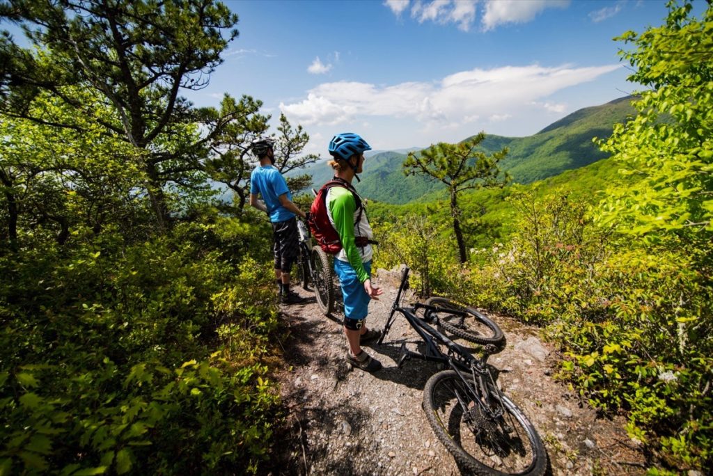
Biking the Blue Ridge Parkway
Pedal your way through stunning mountain scenery on one of America’s most iconic cycling routes. The Blue Ridge Parkway is a dream destination for cyclists, offering more than 469 miles of winding, scenic roadways designed for breathtaking rides and rewarding climbs. Due to extreme elevation changes, ever-changing weather conditions, and significant distances between developed areas of the Parkway, cycling is recommended for experienced road cyclists. Once you prep for your ride and proceed with caution, you’ll find countless routes, overlooks, and bike-friendly stops along the way. Plan your Parkway biking adventure and experience the Blue Ridge Mountains at your own pace.
Regulations & Safety
Cycling the Blue Ridge Parkway is a magnificent experience, but safety is the top priority. Bicycle riders must comply with all applicable state and federal motor vehicle regulations.
Riding Conduct & Placement
- Road Use: Bicycles may be ridden only on paved road surfaces and parking areas. Bicycles, including mountain bikes, are prohibited on all trails or walkways.
- Lane Position: Bicycles must be ridden single file and well to the right-hand side of the road, except when passing or turning left.
- Group Riding: When cycling in a group, adjust your spacing to safely allow motor vehicles to pass.
- Helmet Use: Wear a bicycle helmet. While North Carolina law mandates it for persons 16 and under (and many Virginia counties do as well), it is strongly recommended for riders of all ages.
Visibility, Gear & Weather
- Lights: The bicycle operator must exhibit a white light or reflector visible at least 500 feet to the front and a red light or reflector visible at least 200 feet to the rear during periods of low visibility (including tunnels) and between the hours of sunset and sunrise.
- Gear: Ensure your bicycle is in good operating condition and carry a spare tube and tools for minor repairs. Wear high visibility clothing to ensure motorists can see you against the scenic background.
- Weather Caution: Avoid the Parkway during periods of low visibility. Fog and rain can occur unpredictably, especially at high elevations. Reschedule your trip or follow lower elevation routes until conditions improve.
Tunnel Navigation & Trip Logistics
- Tunnels: Exercise extreme caution when traveling through tunnels. The Parkway has 25 tunnels in North Carolina and 1 in Virginia. Check our tunnels page or downloadable mobile application for tunnel locations and heights.
- Resupply: Water, food, and lodging are only available seasonally in some areas. Know where you will stay and how you will resupply food and water before you leave.
- Parking: Contact Parkway dispatch at 828-298-2491 before leaving a motor vehicle parked along the Parkway overnight.
Major Uphill Climbs Traveling Southbound
| MILEPOST | ELEVATION GAIN IN FEET |
| 0 – 3.0 | 391 |
| 4.7 – 8.5 | 1,100 |
| 9.2 – 10.7 | 322 |
| 18.5 – 23.0 | 785 |
| 37.4 – 38.8 | 229 |
| 42.0 – 43.9 | 570 |
| 47.0 – 49.3 | 405 |
| 63.0 – 76.7 | 3,305 |
| 89.1 – 91.6 | 569 |
| 93.1 – 95.4 | 428 |
| 118.1 – 120.4 | 426 |
| 127.0 – 132.5 | 1,400 |
| 134.0 – 134.9 | 195 |
| 136.4 – 138.2 | 275 |
| 150.6 – 152.1 | 278 |
| 157.0 – 157.6 | 200 |
| 164.7 – 168.0 | 830 |
| 169.5 – 170.1 | 260 |
| 176.2 – 177.0 | 212 |
| 186.6 – 188.8 | 360 |
| 195.0 – 196.2 | 235 |
| 197.6 – 198.7 | 210 |
| 200.5 – 201.5 | 335 |
| 216.6 – 217.7 | 240 |
| 231.3 – 233.1 | 550 |
| 233.7 – 235.2 | 280 |
| 235.8 – 236.9 | 365 |
| 240.0 – 240.8 | 170 |
| 249.0 – 249.8 | 235 |
| 251.3 – 252.8 | 300 |
| 263.6 – 264.6 | 360 |
| 265.2 – 266.8 | 270 |
| 269.8 – 271.1 | 330 |
| 271.4 – 273.1 | 575 |
| 276.4 – 277.4 | 375 |
| 281.7 – 282.4 | 280 |
| 282.7 – 283.8 | 255 |
| 286.0 – 287.8 | 500 |
| 288.7 – 289.9 | 250 |
| 291.8 – 293.8 | 400 |
| 298.6 – 302.1 | 1,005 |
| 316.4 – 318.2 | 380 |
| 318.5 – 320.7 | 590 |
| 330.9 – 332.1 | 410 |
| 332.6 – 334.5 | 545 |
| 336.3 – 338.9 | 540 |
| 345.4 – 349.9 | 1,480 |
| 351.9 – 355.0 | 920 |
| 355.4 – 358.5 | 520 |
| 361.1 – 364.1 | 500 |
| 393.8 – 396.4 | 920 |
| 397.3 – 399.7 | 430 |
| 400.3 – 405.5 | 965 |
| 405.7 – 407.7 | 745 |
| 416.8 – 420.2 | 1,100 |
| 423.2 – 424.8 | 230 |
| 426.5 – 428.2 | 405 |
| 429.0 – 431.4 | 600 |
| 443.1 – 451.2 | 2,450 |
| 455.7 – 458.9 | 810 |
| Total Elevation Gain Southbound | 48,601 |
Statistics courtesy of Tom De Vaughn, Troutville, Virginia.
Major Uphill Climbs Traveling Northbound
| MILEPOST | ELEVATION GAIN IN FEET |
| 469.1 – 462.2 | 2,240 |
| 461.6 – 458.9 | 1,000 |
| 455.7 – 451.2 | 1,480 |
| 443.1 – 435.5 | 2,020 |
| 433.3 – 431.4 | 475 |
| 426.5 – 424.8 | 325 |
| 423.2 – 421.6 | 250 |
| 415.6 – 413.2 | 385 |
| 411.9 – 409.6 | 400 |
| 383.5 – 376.7 | 1,135 |
| 375.3 – 364.1 | 2,535 |
| 361.1 – 358.5 | 540 |
| 351.9 – 349.9 | 565 |
| 334.1 – 341.8 | 530 |
| 339.8 – 338.9 | 260 |
| 336.3 – 335.7 | 215 |
| 327.4 – 325.8 | 290 |
| 325.0 – 320.7 | 1,210 |
| 316.4 – 312.4 | 520 |
| 309.9 – 306.5 | 460 |
| 305.6 – 305.0 | 200 |
| 295.8 – 293.8 | 555 |
| 291.8 – 289.9 | 275 |
| 285.2 – 283.8 | 400 |
| 279.6 – 278.8 | 270 |
| 276.4 – 273.1 | 910 |
| 269.8 – 268.6 | 315 |
| 268.1 – 266.8 | 380 |
| 257.8 – 256.8 | 200 |
| 248.0 – 244.5 | 495 |
| 243.8 – 242.9 | 270 |
| 242.4 – 241.5 | 300 |
| 240.0 – 239.3 | 160 |
| 238.5 – 237.2 | 270 |
| 220.8 – 220.1 | 205 |
| 215.6 – 214.0 | 260 |
| 210.6 – 209.4 | 220 |
| 199.4 – 198.7 | 165 |
| 189.4 – 188.7 | 220 |
| 175.1 – 171.9 | 575 |
| 168.9 – 168.0 | 185 |
| 159.4 – 157.6 | 389 |
| 150.6 – 149.8 | 226 |
| 140.1 – 139.3 | 229 |
| 136.0 – 134.9 | 285 |
| 124.6 – 123.1 | 320 |
| 121.4 – 120.4 | 265 |
| 115.0 – 113.0 | 280 |
| 106.0 – 103.6 | 500 |
| 102.5 – 99.8 | 820 |
| 93.1 – 91.6 | 374 |
| 89.1 – 87.3 | 634 |
| 85.6 – 84.7 | 230 |
| 83.5 – 76.7 | 1,490 |
| 63.0 – 49.3 | 1,852 |
| 46.4 – 43.9 | 627 |
| 40.0 – 38.8 | 331 |
| 37.4 – 34.0 | 951 |
| 13.7 – 10.7 | 563 |
| 9.2 – 8.5 | 222 |
| 4.7 – 3.0 | 300 |
| Total Elevation Gain Northbound | 48,722 |
Statistics courtesy of Tom De Vaughn, Troutville, Virginia.
DOWNLOAD THE APP
Use our new app as a guide to help make your drive on the Parkway a safe and fun one.
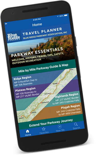
DOWNLOAD THE TRAVEL PLANNER
Map out your Parkway trip with a digital version of our complimentary travel guide.