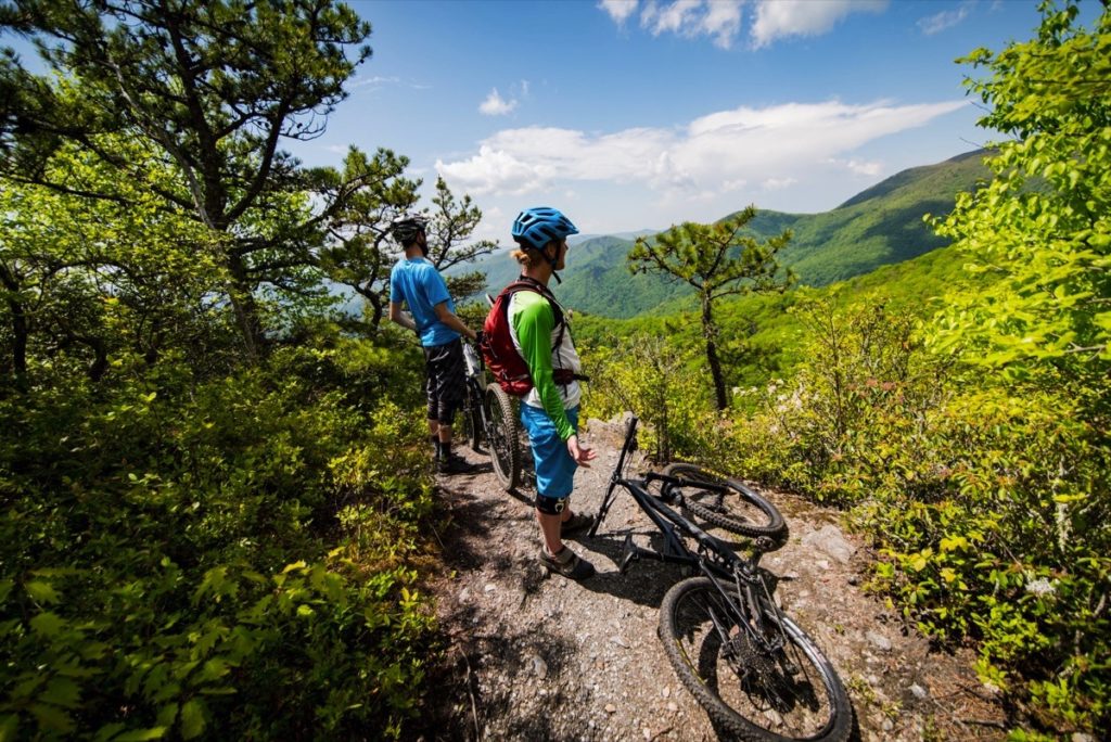
Numerous waterfalls are located throughout the Shenandoah, Great Smoky Mountains and Blue Ridge Parkway (BRP) regions. Some are visible from the road and some require a hike. The list below notes the location and ease of access for each waterfall.
Warning: Waterfalls are beautiful but dangerous and slippery; each year people die while climbing waterfalls or exploring off-trail near waterfalls. Please stay on the trail, view waterfalls from a distance, and return home safely! As a reminder, it is illegal to swim in any waters within the boundaries of the Blue Ridge Parkway.
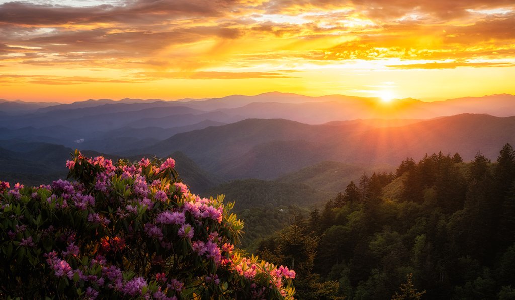
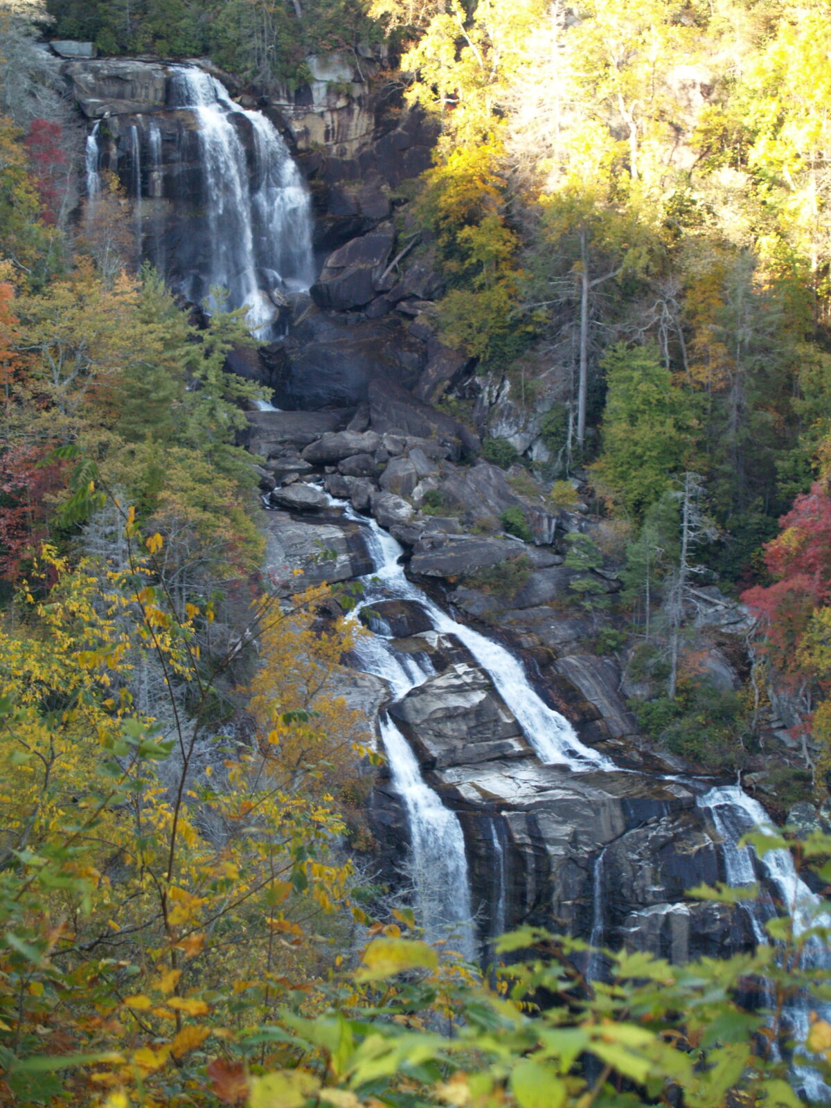
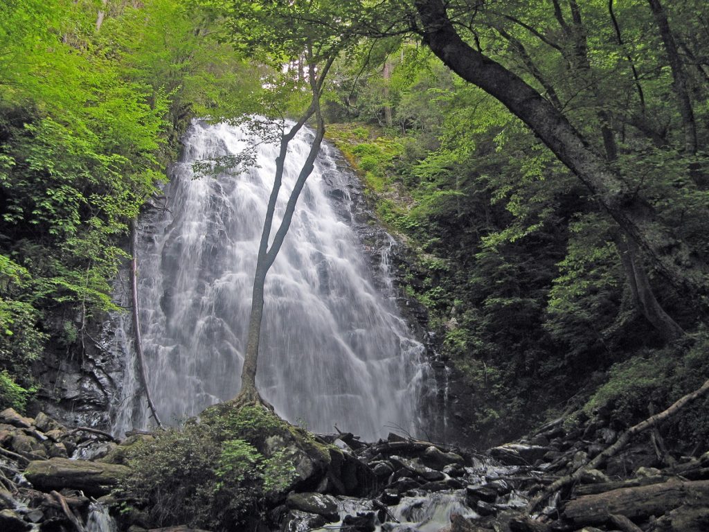
Hero Image: Whitewater Falls
Shenandoah National Park Region – Virginia
North of Blue Ridge Parkway Milepost 0
Skyline Drive traverses Shenandoah National Park from Milepost 0 at the North end of the Park to Milepost 105.4 at Rockfish Gap at the South end of the Park. Maps and more information about Shenandoah National Park waterfalls can be found here. There is an entrance fee for Shenandoah National Park.
Skyline Drive Milepost 21.1 – Overall Run Falls
Access: Parking lot just south of Hogback Overlook.
Distance: Approximately 6.5 miles (round-trip)
Difficulty Level: Strenuous
At 93-feet, this is the tallest falls in the Park. Best viewed before June, as it may dry up during the summer.
Skyline Drive Milepost 41.7 and 42.5 – Skyland Resort
Dining and lodging options at the Skyland Resort, a prime location near the waterfalls in Shenandoah National Park. Newly renovated rooms, cozy historic cabins, suites, and pet-friendly rooms are all available.
Skyline Drive Milepost 42.6 – Whiteoak Canyon Falls
Access: Whiteoak Canyon parking area.
Distance: 4.6 miles (round-trip to the first falls)
Difficulty Level: Moderate
The first and largest of the six falls is 86-feet. You can continue further, but not all the falls are easily accessible from the trail.
Skyline Drive Milepost 45.6 – Cedar Run Falls
Access: Hawksbill Gap parking area.
Distance: 3.4 miles (round-trip)
Difficulty Level: Strenuous
Cedar Run Falls (34-feet) and Whiteoak Canyon Falls can be linked into one strenuous 7.3 mile hike.
Skyline Drive Milepost 49.4 – Rose River Falls
Access: Across from the Fishers Gap Overlook.
Distance: 2.6 miles (round-trip)
Difficulty Level: Moderate
Features up to four cascades in rainy weather.
Skyline Drive Milepost 50.7 – Dark Hollow Falls
Access: Dark Hollow Falls parking area.
Distance: 1.4 miles (round-trip)
Difficulty Level: Moderate
Popular trail to the 70-foot falls. Some sections are steep. No pets are allowed on this trail.
Skyline Drive Milepost 51 and 51.2 – Big Meadows Lodge
Hike the loop trail to Lewis Falls directly from your historic main lodge room or comfortable, rustic motel-like unit when you stay at Big Meadows Lodge. Several other waterfalls are within a short drive.
Skyline Drive Milepost 51.4 – Lewis Falls
Access: Parking lot just south of Big Meadows next to a service road.
Distance: 2.5 miles (round-trip)
Difficulty Level: Moderate
Trail is rocky and steep en route to the 81-foot falls. Best water flow is early in the season or after a good rain.
Skyline Drive Milepost 62.8 – South River Falls
Access: South River picnic area.
Distance: 3.3 miles (round-trip)
Difficulty Level: Moderate
Third tallest waterfall in Shenandoah at 83-feet. Trail takes you to an overlook above the falls. There is also a rocky 1-mile round-trip spur trail that goes to the base of the falls.
Skyline Drive Milepost 81.1 – Doyles River Falls
Access: Doyles River parking area.
Distance: 3.0 miles (round-trip)
Difficulty Level: Moderate
Three mile round-trip to see upper (28-feet) and lower falls (63-feet), or you can hike a 7.8 mile loop that includes Jones Run Falls.
Skyline Drive Milepost 84.1 – Jones Run Falls
Access: Jones Run parking area.
Distance: 3.6 miles (round-trip)
Difficulty Level: Moderate
3.6 mile round-trip to see 42-foot Jones Run Falls or make it a longer loop to include Doyles River Falls.
Waynesboro, VA offers easy access to the waterfalls along the southern end of Skyline Drive and the northern end of the Blue Ridge Parkway!
Ridge Region – Virginia
Blue Ridge Parkway Milepost 0-106
Rockfish Gap, part of the Ridge Region, at the southern end of Shenandoah National Park marks the northern starting point of the Blue Ridge Parkway at its Milepost 0. There is no entrance fee to visit the Blue Ridge Parkway.

BRP Milepost 19.9 – White Rock Falls
Access: Across the Parkway from Slacks Overlook (and just a bit North toward Milepost 19.8, nondescript trailhead with roadside parking only and minimal signage).
Distance: 1.8 miles (round-trip to the falls and back)
Difficulty Level: Moderate
Also accessible from Milepost 18.5 (White Rock Gap Trail parking) for a 3.4-mile round trip. Or make it a 4.7-mile loop by linking the White Rock Gap and Slacks Trails with the White Rock Falls Trail. See map for details. (Note: Copperhead and rattlesnake sightings are reported at the rocky overlooks along this trail as you hike downhill from the access near Milepost 19.9)
Exit BRP at Milepost 27.2 – Crabtree Falls (VA)
Access: 6.3 miles from Parkway via VA-56 E. Day use fee required. Towing and large vehicles not recommended on VA-56.
Distance: The first overlook is wheelchair accessible via a short, easy walk along a paved trail; 3.4 Miles (round-trip) to four other overlooks with 1,070+ feet of elevation gain and loss.
Difficulty Level: Moderate
Five major (and several minor) cascades totaling 1,200 feet; considered the highest waterfall east of the Mississippi River. Crabtree Falls is located in the Glenwood-Pedlar Ranger District of the George Washington & Jefferson National Forests.
BRP Milepost 34.4 – Wigwam Falls
Access: Yankee Horse Ridge Parking Area
Distance: 0.2 mile (entire loop)
Difficulty Level: Moderate
Reconstructed narrow-gauge railroad track forms part of the trail. Viewing bridge is located beneath the 30-foot falls.
BRP Milepost 78.4 – Apple Orchard Falls
Access: Sunset Fields Overlook
Distance: 2.4 miles (round-trip)
Difficulty Level: Strenuous. The hike to the falls drop 1,000+ feet on the way down. It’s all uphill on the return trip.
Viewing platform directly underneath the falls.
BRP Milepost 83.1 – Fallingwater Cascades
Access: Fallingwater Cascades Overlook
Distance: Approximately 1.6 miles (round-trip for the whole loop)
Difficulty Level: Moderate
Plateau Region – Virginia to NC State Line
Blue Ridge Parkway Milepost 106-217
Exit the Blue Ridge Parkway and head west to access the Plateau Region and the Jefferson National Forest, the Little Stony National Recreation Trail, and the spectacular 776-acre public Pinnacle Natural Area Preserve containing interesting flora, fauna and geologic features — including Big Falls on Big Cedar Creek — in the Heart of Appalachia, where waterfalls abound.
Highlands Region – North Carolina
Blue Ridge Parkway Milepost 217-340
The Highlands Region of the Blue Ridge Parkway is famous for its rugged terrain and high rainfall, making it a spectacular area for waterfall viewing. This central section of the parkway in North Carolina offers incredible access to powerful cascades and picturesque streams.
BRP Milepost 243.7 – Basin Creek Trail
Access: Use the Bluff Mountain Trail and Grassy Gap Fire Road.
Distance: 17.8 miles (round-trip) to the Caudill Cabin and back from the Bluff Mountain. Trailhead at Milepost 243.7
Difficulty Level: Easy to Moderate
Basin Creek Trail, accessible only from the Grassy Gap Fire Road, winds past cascading waterfalls for 3.3 miles to the century-old Caudill Cabin. Check out the Doughton Park map for details.
BRP Milepost 271.9 – Cascades
Access: Cascades Overlook
Distance: 1.0 mile (round-trip)
Difficulty Level: Easy to Moderate (some steep stairs)
Intersects the Tompkins Knob and Mountains to Sea Trails.
BRP Milepost 296.4 – Boone Fork Falls (also called Hebron Falls)
Access: Julian Price Park picnic area across the bridge near the restrooms.
Distance: 2.8 Miles (to the falls and back hiking counterclockwise on the Boone Fork Trail) or 4.9 Miles (round-trip for the whole loop)
Difficulty Level: Moderate to Strenuous (some steep stairs and ladders and multiple stream crossings that can be difficult after rain)
BRP Milepost 305.2 – Otter Falls
Access: Exit BRP at Milepost 305.2
Distance: 1.2 mile (round-trip) hike
Difficulty Level: Moderate
See Otter Falls on a moderate hike off of Skyland Drive in Seven Devils. Several loop trails offer various options for your return trek.
BRP at Milepost 312 – South Mountains State Park
Access: Exit BRP at Milepost 312 and travel South on NC-181
Distance: Multiple options
Difficulty Level: Moderate to Strenuous
Visit Burke County, Nature’s Playground, and view one of several waterfalls in South Mountains State Park. If nature’s your thing, come explore the almost 12,000 acres of Linville Gorge Wilderness Area!
BRP Milepost 316.4 – Linville Falls
Access: Parking lot at end of Linville Spur Road.
The powerful Linville Falls is a stunning three-tiered waterfall cascading into the Linville Gorge, known as the “Grand Canyon of the East.” Located just off the Parkway, the area features multiple trails – including the wheelchair accessible Duggers Creek Trail – of varying difficulty, providing accessible views of the Upper Falls and challenging access to the Lower Falls.
Linville Falls Trail (View of Upper Falls)
Distance: 1.6 miles (round-trip)
Difficulty Level: Moderate
Linville Gorge Trail (View of Lower Falls)
Distance: 1.0 mile (round-trip)
Difficulty Level: Strenuous
Duggers Creek Loop Trail (View of Duggers Falls)
Distance: 0.3 mile (round-trip for the whole loop)
Difficulty Level: Easy
Erwins View Trail (Views of Upper Falls & Lower Falls)
Distance: 1.6 miles (round-trip)
Difficulty Level: Moderate
BRP Mileposts 316 to 344 – McDowell County
Access: Varies, depending on the trail
Distance: 1+ miles, depending on the trail
Difficulty Level: Easy to Strenuous
McDowell County features the spectacular region of the Blue Ridge Parkway between Linville Falls and Crabtree Falls, Mileposts 316 to 344. And more waterfalls are located off the BRP! Exit at Milepost 317.4 for Tom’s Creek Falls, an 80-foot multi-cascade waterfall on an easy 1 mile round-trip hike just 1.2 miles from US-221. Catawba Falls is a 280-foot multi-cascade on a moderate to strenuous 4.3 mile round-trip hike off of Catawba River Road just west of Old Fort, only 30 minutes from Tom’s Creek Falls.
BRP Milepost 317.4 – Cross Creek Cabins
Access: Exit BRP at Milepost 317.4
Cross Creek Cabins features five fully-furnished log cabins available to rent year-round within walking distance of Linville Falls. Whether you play in town or hike all day, these cabins located on 25 scenic acres will be a respite for you and your pet during your stay.
Exit BRP at Milepost 333.9 – Grassy Creek Falls
Access: 0.7 miles from Parkway via High Ridge Road and Blands Knob
Distance: 1.5 miles (round-trip)
Difficulty Level: Easy
Multi-level cascade located on private property requires walking partway on a gravel drive with some steep grades.
Exit BRP at Milepost 333.9 – Bon Ami Waterfall
See the Bon Ami Waterfall, but you can also experience North Carolina mining history at the NC Mining Museum and tour the underground Bon Ami mine. Emerald Village is home to 12 historic real mines and houses an impressive collection of old mining and historical equipment. Portions of the site are handicap accessible.
BRP Milepost 339.5 – Crabtree Falls (NC)
Access: Crabtree Falls Campground. If using a GPS or Google maps, please note that Crabtree Falls is accessed DIRECTLY from the Blue Ridge Parkway; it is NOT located on Crabtree Road. The closest Google maps address to use for the Crabtree Falls trailhead is 39000 Blue Ridge Parkway, Marion, NC 28752.
Distance: 1.8 miles (round-trip to the falls and back) or 2.5 to 3 miles (round trip for the whole loop) depending on the route
Difficulty Level: Moderate to Strenuous
At the Crabtree Falls, water cascades over a 60-foot rock cliff.
Pisgah Region – North Carolina
BRP Milepost 340-469
The Pisgah Region covers the mountainous southern stretch of the Parkway, offering incredible biodiversity and the highest peaks east of the Mississippi. This area is home to numerous impressive waterfalls and cascades, often reached via rugged but rewarding trails that connect to the Pisgah National Forest.

Exit BRP at Milepost 344.1 – Roaring Fork Falls
Access: 2.6 miles from Parkway via NC-80 N., S. Toe River River Road & Busick Work Center Road (Continue on S. Toe River Road to reach Setrock Creek Falls)
Distance: 1.4 miles (round-trip)
Difficulty Level: Easy
The 100-foot cascade is worth the walk.
Exit BRP at Milepost 344.1 – Setrock Creek Falls
Access: 5.5 Miles from Parkway via NC-80 N. and S. Toe River River Road. Park outside the Black Mountain Campground and walk in across the bridge toward the Mt. Mitchell Trail, then look for the Setrock Creek Falls trailhead past the Mt. Mitchell Trail.
Distance: 1.0 Mile (round-trip)
Difficulty Level: Easy
75-foot waterfall that provides an excellent show after a good rain.
BRP Milepost 344.1 – Alberts Lodge
Access: Exit BRP at Milepost 344.1
Stay year-round at Alberts Lodge, near Mount Mitchell. Enjoy the inn or a cottage with views of the Black Mountains and walk to Roaring Fork Falls. Located just two minutes from the Parkway!
BRP Milepost 361.2 – Glassmine Falls
Access: Glassmine Falls Overlook at Milepost 361.2.
Falling along an 800-foot cliff across the valley, this wheelchair accessible waterfall is most visible after heavy rains and when leaves are off the trees.
BRP Milepost 363.4 – Douglas Falls
Access: Graybeard Mountain Overlook
Distance: 8.0 miles (round-trip)
Difficulty Level: Strenuous
From the overlook, follow the Mountains to Sea Trail South for one mile to the junction with the Falls Trail, then travel three miles on the Falls Trail to the 70-foot Douglas Falls, past a series of cascades.
BRP Milepost 384.7 – Hickory Nut Falls & Catawba Falls
Located just 20 Miles from Parkway via US-74 ALT E, you can view 404-foot Hickory Nut Falls featured in the movie “The Last of the Mohicans,” hike the trails, and enjoy the panorama from Chimney Rock State Park (exit the BRP at Milepost 384.7). Take the stairs or the elevator; it’s an experience either way! Check the park website for details about which parking lots are open, as this will determine how long and difficult your hike is. Head east of Asheville via I-40 to Catawba Falls, a 100-foot multi-cascade on a moderate 2.1 mile round-trip hike off of Catawba River Road just West of Old Fort.
BRP at Milepost 384.7 or 393.6 – Bradley Falls
Access: Exit BRP at Milepost 384.7 or 393.6 and head southeast to Polk County
Distance: 0.5+ miles
Difficulty Levels: Easy to Moderate
Enjoy Big Bradley Falls (moderate hike), Drip Falls (moderate hike), Emily Falls (a short, easy hike to 12-foot falls), Little Bradley Falls (moderate hike), Pearson’s Falls (no pets, day use fee required, moderate 0.5 mile round-trip trail to see the 90-foot falls) and Shunkawauken Falls (visible from roadside pull offs for wheelchair access) among the charming towns of Tryon, Saluda and Columbus.
BRP at Milepost 388.8, 393.6, or 411.8 – DuPont State Recreational Forest
Access: Exit BRP at Milepost 388.8, 393.6, or 411.8
Explore Henderson County, from Hendersonville’s historic downtown to the Flat Rock Playhouse to the waterfalls of DuPont State Recreational Forest, and then stop in for a locally-brewed beer or cider.
BRP Milepost 411.8 – Transylvania County
Access: Exit BRP at Milepost 411.8
Visit North Carolina’s Land of Waterfalls, Transylvania County. In addition to several waterfalls that you can hike to, including the wheelchair accessible Looking Glass Falls (9.5 Miles from the Parkway via US-276 S), Pisgah National Forest is accessible to everyone because it is visible from the roadside. Learn more about waterfalls in Transylvania County.
Exit BRP at Milepost 411.8 – Upper Whitewater Falls
Access: 45.2 miles from BRP via US-276 S & US-64 W; day use fee required
Distance: 0.25 mile (one-way) to upper platform, lower viewing platform is an additional 0.5 mile (one-way) down a steep set of 150+ steps for a round-trip of 1.5 miles
Difficulty Level: Easy to Moderate
Very popular 411-foot falls borders Jackson County. These falls are pictured at the beginning of this story. The first overlook is wheelchair accessible.
BRP Milepost 417 – Skinny Dip Falls
Access: Across from the Looking Glass Rock Overlook.
Distance: 0.9 Mile (round-trip)
Difficulty Level: Moderate (rocks, roots and a very steep staircase that descends to the river)
On August 17, 2021, Tropical Storm Fred caused major flooding in this area that rearranged the stream topography and washed away the bridge across the stream. According to the Friends of the Mountains-to-Sea Trail, new steps and rockwork lead to an unbridged stream crossing that is passable for hikers of average ability. While the trail has now reopened, there is no longer a deep pool to jump or swim in or recognizable falls to visit.
BRP Milepost 418.8 – Graveyard Fields Falls
Access: Graveyard Fields Overlook.
Distance: 2.9 Miles (round-trip)
Difficulty Level: Moderate
Both falls are accessible on a 2.9-mile trek, starting with Lower Falls and then going on to Upper Falls. Wild blueberries grow along the route. The trail is not well marked and there are many side trails because the area sees heavy use. Lower Falls is visible from the Parkway for wheelchair access.
BRP at Milepost 423.3 – Courthouse Falls
Access: Exit BRP at Milepost 423.3 and head South on NC-215 for 6.7 miles
Distance: 0.7 mile (round-trip)
Difficulty Level: Easy
Enjoy a short, easy hike to Courthouse Falls. Then rejuvenate overnight at Trout House Falls Luxury Waterfront Vacation Rentals. Listen to a rushing waterfall as you sleep, watch the stream cascade by, or fish in the French Broad River. Whether you hike and bike, relax, or reunite with family and friends, these cabins offer a perfect tranquil setting.
BRP at Milepost 443.1, 455.7, or 469.1 – Jackson County Falls
Access: Exit BRP at Milepost 443.1, 455.7, or 469.1
Distance: 0.5+ miles, depending on the trail
Difficulty Levels: Easy to Moderate/Strenuous
Head to Jackson County, where there are more waterfalls than you can shake a stick at, such as High Falls or Cullowhee Falls (1.5 mile moderate to strenuous hike; the flow varies based on how much water is released from the dam and the amount of rain) and Silver Run Falls (25-foot falls with a swimming hole on a 0.5 Mile round-trip easy trail). Another beauty, 411-foot Upper Whitewater Falls, is close to the South Carolina state line and borders Transylvania County (see Milepost 411.8 for details).
Exit BRP at Milepost 455.7 – Soco Falls
Access: 1.5 miles from Parkway at Soco Gap via US-19 S. Drive just 0.03 mile past the small blue sign stating “Soco Falls ½ mile ahead.” Parking can be challenging during busy times as there is just a wide shoulder on the left side of the road.
Distance: short walk on a maintained trail to a viewing platform
Beautiful 120-foot double waterfall (pictured above) flows into the rocky stream below. From the viewing platform, there is a steep, slippery trail to the base of the falls.
Great Smoky Mountains National Park Region – North Carolina & Tennessee
Southwest of BRP Milepost 469
The southern end of the Blue Ridge Parkway at Milepost 469 serves as a gateway to the spectacular Great Smoky Mountains National Park, which straddles the border of North Carolina and Tennessee. This iconic National Park features some of the Appalachian region’s most famous and powerful waterfalls, offering rewarding hikes and unparalleled natural beauty.

BRP at Milepost 469.1 – Bryson City & Swain County Falls
Exit BRP at Milepost 469.1 to visit the waterfalls of Bryson City & Swain County. Some of the favorites are the wheelchair accessible Tom’s Branch (via a 0.6 mile round-trip relatively flat gravel path), Indian Creek and Juney Whank Falls (see both on a 1.6 mile round-trip easy trail) in the Deep Creek area of the Great Smoky Mountains National Park. In nearby Franklin, you’ll find Rufus Morgan Falls (1.0 mile moderate loop trail) and Big Laurel Falls (1.1 mile round-trip easy trail) in Nantahala National Forest and wheelchair accessible Upper & Lower Cullasaja Falls (visible from US-64). Continuing to the Highlands, you’ll discover the wheelchair accessible Dry Falls (a 75-foot falls that you can walk behind via a short trail), wheelchair accessible Bridal Veil Falls (drive under this 45-foot falls at a pull off along the road, pictured above) and Glen Falls (a triple waterfall which requires some hiking).
BRP at Milepost 469.1 – Great Smoky Mountains National Park Falls
Also exit BRP at Milepost 469.1 to enter the Great Smoky Mountains National Park along US-441. Many waterfalls are scattered throughout the Park, some requiring hiking and some handicap accessible (reachable via vehicle). Take a look at a map and descriptions of the falls. There is no entrance fee to visit the Great Smoky Mountains National Park.