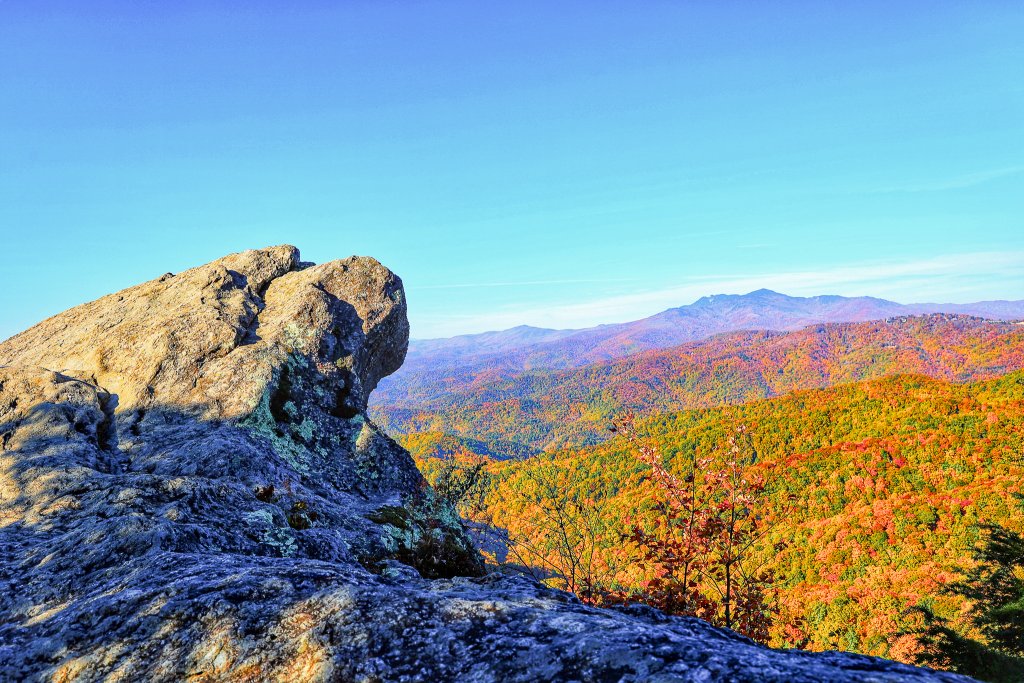
Hiking on the Blue Ridge Parkway
Step into the natural beauty of the Blue Ridge Parkway, where hundreds of hiking trails connect to waterfalls, overlooks, and ancient forests. From short, family-friendly walks to challenging backcountry treks, the Parkway offers hikes for every level and season. Explore trails leading to stunning views of the Appalachian Mountains or discover the quiet magic of mossy woods and mountain streams. Lace up your boots and find your next unforgettable hike along the Blue Ridge Parkway.

Meandering alongside and crossing the scenic motor road, the trails provide a close-up look at some of the most beautiful wilderness in the country. Many trails wind their way through unique biological and geological environments. Others lead to historic sites with stories of how people have shaped our heritage.
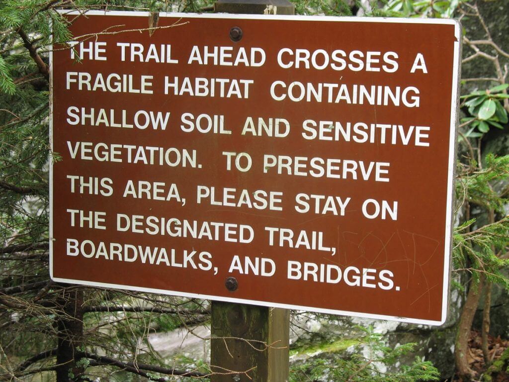
Many Parkway trails continue onto Forest Service and private land. Please respect all these lands and treat them with care. Every trail and overlook should be treated with respect using these 7 principles from Leave No Trace.
Virginia Trails by Milepost
Mileage is one-way from the trailhead unless the trail is a loop.
Milepost 5.9
Mountain Farm Trail
Self-guided walk from the Visitor Center to the pioneer farmstead. (Info & Map)
Length: 0.25 Miles Skill Level: Easy
Milepost 6
Appalachian Trail
Section from Humpback Gap parking area to the summit of Humpback Mountain (3650 ft. elevation).
Length: 2 Miles Skill Level: Strenuous
Milepost 8.4
Catoctin Loop Trail
Short loop perfect for a quick leg stretcher.
Length: 0.3 Miles Skill Level: Moderate
Milepost 8.8
Greenstone Trail
Self-guided trail focusing on the Greenstone geology formation and oak hickory forest.
Length: 0.2 Miles Skill Level: Moderate
Milepost 17.6
The Priest
Short trail leading to a scenic viewpoint.
Length: 0.1 Miles Skill Level: Easy
Milepost 18.5
White Rock Falls Trail Connection
Connects to the White Rock Falls Trail for an extended hike.
Length: 2.9 Miles Skill Level: Moderate
Milepost 20
White Rock Falls Trail
Follows a stream to a small waterfall. Two access points: 1) North toward Milepost 19.8, minimal signage and nondescript trail. Note: Watch for snake sightings near rocky overlooks. 2) Milepost 18.5 from the White Rock Gap Trail parking area (3.4 miles roundtrip), or enjoy a 4.7 mile loop by linking the White Rock Gap and Slack Trails with the White Rock Falls Trail. (Map)
Length: 0.9 Miles Skill Level: Moderate
Milepost 26.3
Big Spy Mountain
Short trail leading to an expansive overlook of the Shenandoah Valley, great for stargazing.
Length: 0.1 Miles Skill Level: Moderate
Milepost 34.4
Yankee Horse
Trail to a logging railroad exhibit and small waterfall.
Length: 0.2 Miles Skill Level: Moderate
Milepost 38.8
Boston Knob
A quick, leg stretching loop trail.
Length: 0.1 Miles Skill Level: Easy
Milepost 47.5
Indian Gap
Trail to Indian Rocks with a beautiful seasonal rhododendron display.
Length: 0.3 Miles Skill Level: Moderate
Milepost 55.2
White Oak Flats
A quick, leg stretching loop trail.
Length: 0.1 Miles Skill Level: Easy
Milepost 60.8
Otter Creek Trail
Begins at the Otter Creek Campground and follows the creek bottom. (Info & Map)
Length: 3.5 Miles Skill Level: Moderate
Milepost 63.1
Otter Lake Trail
A loop hike that circles Otter Lake. (Info & Map)
Length: 0.8 Miles Skill Level: Moderate
Milepost 63.6
James River Trail
Self-guided trail leading to the historic canal locks. (Info & Map)
Length: 0.2 Miles Skill Level: Easy
Milepost 63.6
Trail of Trees Trail
Self-guided trail leading to the James River Overlook. (Info & Map)
Length: 0.5 Miles Skill Level: Moderate
Milepost 74.7
Thunder Ridge Trail
Leg stretcher loop offering an overlook of Arnold Valley.
Length: 0.1 Miles Skill Level: Easy
Milepost 78.4
Apple Orchard Falls Trail
National Recreation Trail leading to a viewpoint of Apple Orchard Falls.
Length: 1.2 Miles Skill Level: Strenuous
Milepost 79.7
Onion Mountain Loop Trail
Short leg stretcher loop through Appalachian deciduous forest with rhododendron display.
Length: 0.1 Miles Skill Level: Easy
Milepost 83.1
Fallingwater Cascades Trail
National Recreation Trail loop to a viewpoint of the cascades.
Length: 1.6 Miles Skill Level: Moderate
Milepost 83.5
Flat Top Trail
Trail leading to the summit of the highest of the three prominent peaks in the area. (Info & Map)
Length: 4.4 Miles Skill Level: Moderate
Milepost 83.5
Cross Rock Trail
Spur trail off Flat Top Trail featuring unique geological formations.
Length: 0.1 Miles Skill Level: Moderate
Milepost 85.7
Abbott Lake Trail
Easy loop trail circling Abbott Lake.
Length: 1.0 Miles Skill Level: Easy
Milepost 85.9
Elk Run Trail
Self-guiding loop nature trail starting from the Peaks of Otter Visitor Center.
Length: 0.8 Miles Skill Level: Easy
Milepost 85.9
Johnson Farm Loop Trail
Loop trail to the restored mountain farm.
Length: 2.1 Miles Skill Level: Moderate
Milepost 85.9
Harkening Hill Trail
Trail beginning at the Peaks of Otter Visitor Center leading to a 3300 ft. elevation summit.
Length: 3.3 Miles Skill Level: Moderate
Milepost 85.9
Balance Rock
Short spur trail off the Harkening Hill Trail featuring unique geological formations.
Length: 0.1 Miles Skill Level: Moderate
Milepost 86
Sharp Top Trail
Trail to the summit (3875 ft. elevation) offering a 360-degree panoramic viewpoint.
Length: 1.5 Miles Skill Level: Strenuous
Milepost 91
Appalachian Trail
Section from VA 695 to Sharp Top Mountain Overlook.
Length: 1.9 Miles Skill Level: Moderate
Milepost 92.5
Appalachian Trail
Section from Sharp Top Mountain Overlook to Harvey’s Knob Overlook.
Length: 2.9 Miles Skill Level: Moderate
Milepost 95.4
Appalachian Trail
Section from Harvey’s Knob Overlook to Montvale Overlook.
Length: 0.6 Miles Skill Level: Moderate
Milepost 95.9
Appalachian Trail
Section from Montvale Overlook to Taylor’s Mountain Overlook.
Length: 1 Miles Skill Level: Moderate
Milepost 96
Spec Mine Trail
USFS Trail beginning near Montvale Overlook, leading toward State Rt. 645.
Length: 2.8 Miles Skill Level: Strenuous
Milepost 97
Appalachian Trail
Section from Taylor’s Mountain Overlook to Blackhorse Gap.
Length: 0.8 Miles Skill Level: Moderate
Milepost 110.6
Stewarts Knob Trail
Very short trail leading to a scenic viewpoint.
Length: 0.05 Miles Skill Level: Easy
Milepost 114.9
Roanoke River Trail
Self-guiding river loop through the Roanoke Valley. (Info & Map)
Length: 0.35 Miles Skill Level: Easy
Milepost 120.4
Roanoke Mountain Summit Trail
Short trail leading to a summit viewpoint.
Length: 0.11 Miles Skill Level: Moderate
Milepost 120.5
Chestnut Ridge Trail
Loop trail adjacent to the Roanoke Mountain Campground.
Length: 1.75 Miles Skill Level: Moderate
Milepost 121.4
Roanoke Valley Horse Trail
Parallels the Parkway from US Hwy 220 to Milepost 110.6.
Length: 18.5 Miles Skill Level: Moderate
Milepost 123.2
Buck Mountain Trail
Trail to a summit viewpoint.
Length: 0.53 Miles Skill Level: Moderate
Milepost 154.5
Smart View Loop Trail
Loop trail around the picnic area.
Length: 2.6 Miles Skill Level: Moderate
Milepost 167.1
Rock Castle Gorge Trail
Loop from the campground over Rocky Knob and into the gorge.
Length: 10.8 Miles Skill Level: Strenuous
Milepost 167.1
Hardwood Cove Self-Guided Nature Trail
Nature trail that is part of the Rock Castle Loop.
Length: 0.8 Miles Skill Level: Moderate
Milepost 169
Black Ridge Trail
Loop from Rocky Knob Visitor Center to Black Ridge and Grassy Knoll. (Info & Map)
Length: 3.1 Miles Skill Level: Moderate
Milepost 169
Rocky Knob Picnic Loop Trail
Leg stretcher trail around the picnic area.
Length: 1.0 Miles Skill Level: Easy
Milepost 176.2
Mountain Industry Trail
Trail near Mabry Mill exploring local history.
Length: 0.5 Miles Skill Level: Easy
Milepost 179.2
Round Meadow Creek Loop Trail
Walk through a stream bottom forest.
Length: 0.5 Miles Skill Level: Moderate
Milepost 213
High Meadow Trail
Quick leg stretcher loop trail. (Info & Map)
Length: 1.35 Miles Skill Level: Easy
Milepost 213
Fisher Peak Loop
Loop trail near the Blue Ridge Music Center.
Length: 2.25 Miles Skill Level: Moderate
North Carolina Trails by Milepost
Mileage is one-way from the trailhead unless the trail is a loop.
Milepost 217.5
Cumberland Knob Trail
Ideal lazy-day walk near the Parkway’s historical beginning. (Info & Map)
Length: 0.5 Miles Skill Level: Easy
Milepost 217.5
Gully Creek Trail
Rewarding loop that meanders along a stream.
Length: 2 Miles Skill Level: Strenuous
Milepost 218.6
Fox Hunters Paradise Trail
Short trail leading to a scenic viewpoint.
Length: 0.2 Miles Skill Level: Easy
Milepost 230.1
Little Glade Millpond
Easy loop stroll around the millpond.
Length: 0.4 Miles Skill Level: Easy
Milepost 238.5
Cedar Ridge Trail
Great day hike with rewarding vistas and forest scenery. (Info & Map)
Length: 4.2 Miles Skill Level: Moderate
Milepost 238.5
Bluff Mountain Trail
Trail that parallels the Parkway to Milepost 244.7.
Length: 7.5 Miles Skill Level: Moderate
Milepost 241
Fodder Stack Trail
Trail featuring a great variety of plants and scenic views.
Length: 2.89 Miles Skill Level: Strenuous
Milepost 243.7
Grassy Gap Fire Road
Wide road suitable for side-by-side hiking.
Length: 6.5 Miles Skill Level: Moderate
Milepost 243.7
Basin Creek Trail
Trail accessed from the backcountry campground.
Length: 3.3 Miles Skill Level: Moderate
Milepost 244.7
Flat Rock Ridge Trail
Forest path offering scenic vistas.
Length: 5.0 Miles Skill Level: Moderate
Milepost 260.3
Jumpingoff Rocks Trail
Forest path leading to a vista viewpoint.
Length: 1.0 Miles Skill Level: Easy
Milepost 264.4
The Lump Trail
Short trail leading to a hilltop viewpoint.
Length: 0.3 Miles Skill Level: Easy
Milepost 271.9
Cascades Trail
Self-guided loop to a viewpoint of the falls.
Length: 0.5 Miles Skill Level: Moderate
Milepost 272.5
Tompkins Knob Trail
Trail leading to the historic Jesse Brown Cabin.
Length: 0.6 Miles Skill Level: Easy
Milepost 294
Rich Mountain Carriage, Horse, & Hiking Trail
Trail suitable for multiple uses through the park’s scenic areas. (Info & Map)
Length: 3 Miles Skill Level: Moderate
Milepost 294
Flat Top Mountain Carriage, Horse & Hiking Trail
Multi-use trail with access to Flat Top Mountain.
Length: 3 Miles Skill Level: Moderate
Milepost 294
Watkins Carriage, Horse & Hiking Trail
Multi-use trail suitable for easy to moderate hiking.
Length: 3.3 Miles Skill Level: Easy/Moderate
Milepost 294
Black Bottom Carriage, Horse, & Hiking Trail
Short, multi-use trail through the park’s historic area.
Length: 0.5 Miles Skill Level: Easy
Milepost 294
Bass Lake Carriage, Horse & Hiking Trail
Easy loop trail circling Bass Lake.
Length: 1.7 Miles Skill Level: Easy
Milepost 294
Deer Park Carriage, Horse, & Hiking Trail
Multi-use trail through a scenic forested area.
Length: 0.8 Miles Skill Level: Moderate
Milepost 294
Maze Carriage Horse & Hiking Trail
Multi-use trail winding through the estate grounds.
Length: 2.3 Miles Skill Level: Moderate
Milepost 294
Duncan Carriage, Horse, & Hiking Trail
Multi-use trail suitable for moderate hiking.
Length: 2.5 Miles Skill Level: Moderate
Milepost 294
Rock Creek Bridge Carriage, Horse, & Hiking Trail
Easy multi-use trail leading to the bridge viewpoint.
Length: 1.0 Miles Skill Level: Easy
Milepost 294.1
Figure 8 Trail
Short, self-guided loop nature trail.
Length: 0.7 Miles Skill Level: Easy
Milepost 294.6
Trout Lake Hiking & Horse Trail
Easy loop trail around Trout Lake.
Length: 1.0 Miles Skill Level: Easy
Milepost 295.9
Green Knob Trail
Trail to the Green Knob viewpoint. (Info & Map)
Length: 2.3 Miles Skill Level: Moderate/Strenuous
Milepost 296.4
Boone Fork Trail
Trail featuring a stream, forest, and meadows.
Length: 4.9 Miles Skill Level: Moderate/Strenuous
Milepost 297
Price Lake Loop Trail
Scenic loop trail circling Price Lake.
Length: 2.3 Miles Skill Level: Moderate
Milepost 302.8
Rough Ridge Trail
Part of the Tanawha Trail leading to a scenic boardwalk viewpoint.
Length: 0.8 Miles to boardwalk Skill Level: Moderate
Milepost 304.4
Linn Cove Viaduct Access Trail
Short trail leading to a viewpoint of the Linn Cove Viaduct.
Length: 0.16 Miles Skill Level: Easy
Milepost 305.2
Beacon Heights Trail
Short, 10-minute trail leading to an expansive overlook.
Length: 0.22 Miles Skill Level: Moderate
Milepost 305.2
Tanawha Trail
Long trail featuring diverse biological and geological features. (Info & Map)
Length: 13.5 Miles Skill Level: Easy/Moderate
Milepost 308.2
Flat Rock Trail
Self-guided loop trail to a scenic flat rock.
Length: 0.63 Miles Skill Level: Easy
Milepost 315.5
Camp Creek Trail
Leg stretcher through laurel and rhododendron.
Length: 0.1 Miles Skill Level: Easy
Milepost 316.4
Linville Falls Trail
Trail to a viewpoint of the upper Linville Falls. (Info & Map)
Length: 0.8 Miles Skill Level: Moderate
Milepost 316.4
Linville Gorge Trail
Trail to a viewpoint of the lower Linville Falls.
Length: 0.5 Miles Skill Level: Strenuous
Milepost 316.4
Duggers Creek Trail
Loop trail leading to a viewpoint of Duggers Falls.
Length: 0.25 Miles Skill Level: Easy
Milepost 316.5
Linville River Bridge Trail
Short leg stretcher to a viewpoint of an unusual bridge.
Length: 0.1 Miles Skill Level: Easy
Milepost 320.8
Chestoa View Trail
30-minute loop to a stunning vista overlook.
Length: 0.63 Miles Skill Level: Easy
Milepost 339.5
Crabtree Falls Loop Trail
Loop trail to a viewpoint of the falls, accessed directly from the Parkway. (Info & Map)
Length: 2.5 Miles Skill Level: Strenuous
Milepost 344.1
Woods Mountain Trail
USFS Trail beginning near the Parkway.
Length: 2.0 Miles Skill Level: Moderate
Milepost 350.4
Lost Cove Ridge Trail
USFS Trail leading through scenic ridge area.
Length: 0.6 Miles Skill Level: Moderate
Milepost 351.9
Deep Gap Trail
Short trail leading into USFS lands.
Length: 0.2 Miles Skill Level: Easy
Milepost 355
Bald Knob Ridge Trail
Short trail leading to a scenic viewpoint.
Length: 0.1 Miles Skill Level: Easy
Milepost 355
Big Butt Trail
Trail continuing onto USFS lands near Mount Mitchell.
Length: 0.2 Miles Skill Level: Strenuous
Milepost 361.2
Glassmine Falls
Very short trail to a viewpoint of the falls.
Length: 0.05 Miles Skill Level: Moderate
Milepost 361.2
Craggy Pinnacle Trail
Trail to a panoramic summit overlook.
Length: 0.73 Miles Skill Level: Moderate
Milepost 364.2
Craggy Gardens Trail
Self-guided nature trail through the scenic gardens. (Info & Map)
Length: 0.84 Miles Skill Level: Moderate
Milepost 374.4
Rattlesnake Lodge Trail
Woodland walk near the historic lodge site.
Length: 0.5 Miles Skill Level: Moderate
Milepost 382
Mountain-to-Sea Trail (MST)
Long section of the MST with spring wildflowers and views, accessible from the Folk Art Center.
Length: 7.5 Miles Skill Level: Moderate
Milepost 393.7
Shut-In Trail/MST Trail (Bent Creek-Walnut Cove)
Section of the MST with challenging terrain.
Length: 3.1 Miles Skill Level: Strenuous
Milepost 393.7
Grassy Knob Trail
Steep trail leading to the USFS area.
Length: 0.9 Miles Skill Level: Strenuous
Milepost 393.7
Shut-In Trail/MST Trail (Sleepy Gap-Chestnut Cove)
Section of the MST with moderate terrain.
Length: 0.7 Miles Skill Level: Moderate
Milepost 398.3
Shut-In Trail/MST Trail (Chestnut Cove-Bent Creek Gap)
Challenging section of the MST.
Length: 2.8 Miles Skill Level: Strenuous
Milepost 400.3
Shut-In Trail/MST Trail (Bent Creek Gap-Beaver Dam Gap)
Section of the MST with moderate terrain.
Length: 1.9 Miles Skill Level: Moderate
Milepost 401.7
Shut-In Trail/MST Trail (Beaver Dam Gap-Stoney Bald)
Section of the MST with moderate terrain.
Length: 0.9 Miles Skill Level: Moderate
Milepost 402.6
Shut-In Trail/MST Trail (Stoney Bald-Big Ridge)
Challenging section of the MST.
Length: 1.2 Miles Skill Level: Strenuous
Milepost 403.6
Shut-In Trail/MST Trail (Big Ridge-Mills River Valley)
MST section with a mix of moderate and strenuous terrain.
Length: 1.2 Miles Skill Level: Moderate/Strenuous
Milepost 404.5
Shut-In Trail/MST Trail (Mills River Valley-Elk Pasture Gap)
MST section with a mix of moderate and strenuous terrain.
Length: 1.2 Miles Skill Level: Moderate/Strenuous
Milepost 405.5
Shut-In Trail/MST Trail (Elk Pasture Gap-Mt. Pisgah)
Challenging section of the MST leading to Mount Pisgah.
Length: 1.7 Miles Skill Level: Strenuous
Milepost 407.6
Mt. Pisgah Trail
Trail to the summit viewpoint of Mount Pisgah. (Info & Map)
Length: 1.26 Miles Skill Level: Moderate/Strenuous
Milepost 407.6
Buck Springs Trail
Trail from the Pisgah Lodge area leading to a viewpoint.
Length: 0.1 Miles Skill Level: Strenuous
Length: 1.26 Miles Skill Level: Moderate/Strenuous
Milepost 408.5
Frying Pan Mountain Trail
Trail starting at the Mount Pisgah Campground.
Length: 1.65 Miles Skill Level: Moderate/Strenuous
Milepost 409.6
Frying Pan Mountain Trail
Trail via FS 450 (gravel road, park at signpost and don’t block the gate) to the tower viewpoint.
Length: 0.75 Miles Skill Level: Moderate
Milepost 417
East Fork Trail
USFS Trail access to the Shining Rock Trail System.
Length: 0.1 Miles Skill Level: Easy/Moderate
Milepost 418.8
Graveyard Fields Loop Trail
Loop trail by a stream near the Graveyard Fields overlook.
Length: 2.29 Miles Skill Level: Moderate
Milepost 419.4
John Rock Trail
Short leg stretcher leading to a scenic viewpoint.
Length: 0.1 Miles Skill Level: Easy
Milepost 422.4
Devil’s Courthouse Trail
Trail to a panoramic summit overlook.
Length: 0.42 Miles Skill Level: Moderate/Strenuous
Milepost 427.6
Bear Pen Gap Trail
Trail connecting to the Mountains-to-Sea Trail.
Length: 0.22 Miles Skill Level: Easy
Milepost 431
Richland Balsam Trail
Self-guided loop through the unique spruce-fir forest.
Length: 1.47 Miles Skill Level: Moderate
Milepost 433.8
Roy Taylor Overlook Trail
Paved trail leading to an accessible scenic overlook.
Length: 0.1 Miles Skill Level: Easy
Milepost 451.2
Waterrock Knob Trail
Trail to the summit viewpoint of Waterrock Knob.
Length: 0.6 Miles Skill Level: Moderate/Strenuous
DOWNLOAD THE APP
Use our new app as a guide to help make your drive on the Parkway a safe and fun one.
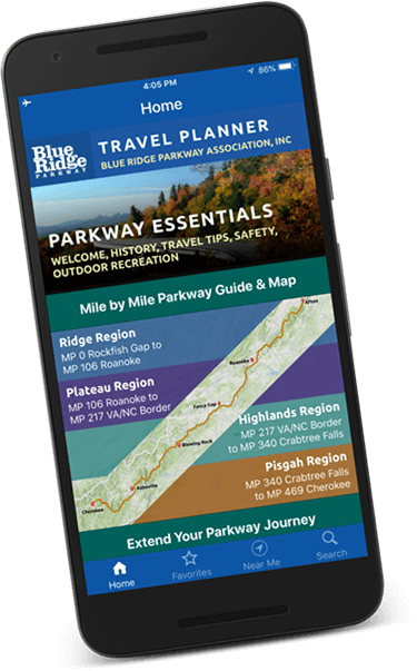
DOWNLOAD THE TRAVEL PLANNER
Map out your Parkway trip with a digital version of our complimentary travel guide.